

Key Takeaways
- CosFly-Track — The first large-scale multi-modal dataset purpose-built for UAV visual tracking, filling a critical gap in aerial visual-language navigation
- 240K multi-modal time steps — 7 synchronized data channels including RGB, depth, semantic segmentation, 6-DoF pose, and bilingual instructions
- MuCO optimization engine — Continuous-space multi-constraint trajectory optimizer that outperforms discrete A* planning by 22× in speed while producing smoother, collision-free trajectories
- 53-69 percentage point improvement — Fine-tuning on CosFly-Track boosts tracking SR@1m across 7 VLM architectures
- Dual-trajectory design — Expert + perturbed trajectory pairs enable denoising, DAgger-style correction, contrastive learning, and prediction training paradigms
- Aomway drone video transmission systems benefit from advances in visual tracking and target-following algorithms — stable visual lock is essential for professional aerial cinematography. Aomway FPV transmission modules support real-time 1080p video feedback essential for visual tracking systems
While aerial visual-language navigation datasets are abundant, almost all are designed for static waypoint navigation. Dynamic target tracking — the core scenario for real-world drone cinematography, search and rescue, and surveillance — has long lacked dedicated large-scale training data. CosFly-Track bridges this gap with 2.4 million multi-modal aligned frames and a continuous-space trajectory optimization pipeline.
Authors: Xiangyue Wang, Hanxuan Chen, Songsheng Cheng, Ruilong Ren, Jie Zheng, Shuai Yuan, Tianle Zeng, Hanzhong Guo, Kangli Wang, Ji Pei
Affiliations: Autel Robotics, Nanjing University, Peking University, Southern University of Science and Technology, The University of Hong Kong
Paper: CosFly-Track: A Large-Scale Multi-Modal Dataset for UAV Visual Tracking via Multi-Constraint Trajectory Optimization — arXiv:2605.17776
Dataset: https://huggingface.co/datasets/AutelRobotics/CosFly
Research Background: The Missing Piece in Aerial VLN
In recent years, aerial visual-language navigation (VLN) technology has advanced rapidly, with datasets growing in scale and diversity. However, one critical gap remains: almost all existing datasets are designed for static waypoint navigation — flying from start to a fixed destination.
In real-world applications — tracking pedestrians, sports cinematography, search and rescue — what drones need is visual tracking capability: continuously following a dynamic target, keeping it in view at all times, while avoiding obstacles and respecting flight dynamics. This fundamentally differs from navigation but has had no dedicated large-scale training data.
Generating high-quality tracking trajectories is inherently harder than navigation paths, facing three technical challenges:
- Discrete planners have inherent flaws: Grid-based algorithms like A* optimize only path length, producing trajectories that violate drone velocity and acceleration limits. Post-processing smoothing introduces residual discretization error.
- Multiple coupled optimization objectives: Tracking must simultaneously optimize target visibility, viewing angle quality, following distance, and obstacle avoidance — all of which change dynamically as the target moves. Navigation tasks don’t need any of these.
- Prohibitively high generation costs at scale: Denser urban scenes and longer trajectories cause exponential search-space explosion. Generating tens of thousands of high-quality trajectories is computationally expensive.
To solve these challenges, the team developed a continuous-space multi-constraint optimization pipeline and built a complete industrial-grade dataset generation system. Aomway follows similar principles in its drone FPV transmission and target-tracking system development, ensuring reliable visual lock in dynamic flight conditions.
Key Contributions
- First dedicated tracking dataset: CosFly-Track is the first large-scale multi-modal dataset purpose-built for UAV visual tracking, containing ~12,000 expert/perturbed trajectory pairs, 2.4 million time steps, 7 time-aligned data channels, and bilingual (Chinese/English) instructions.
- Industrial-grade generation pipeline: The modular CosFly data production pipeline, powered by the MuCO multi-constraint trajectory optimizer, simultaneously optimizes visibility, viewing angle, obstacle avoidance, and motion feasibility in continuous 3D space.
- Comprehensive benchmark validation: Systematic evaluation across 7 mainstream VLM models shows tracking performance improvements of 53-69 percentage points over zero-shot baselines after fine-tuning, plus data scaling and multi-dimensional ablation studies.
- Fully open research resources: The dataset, evaluation scripts, and pre-trained model weights are publicly released to support the entire UAV tracking research community.
Task Definition: Tracking vs. Navigation — Fundamentally Different
The paper provides a clear formal distinction between the two tasks:
- Navigation: Given a fixed target location (or corresponding language instruction), plan a path from start to destination in a static environment. Success is defined as reaching the endpoint.
- Visual tracking: Given a dynamically moving target trajectory, the drone must continuously follow the target, keeping it visible at a reasonable distance while satisfying all kinematic constraints. Success requires stable tracking throughout the entire trajectory — losing the target at any point means failure.
In simple terms: navigation is a single-exam test — just arrive at the destination. Tracking is a continuous exam — every single step counts.
Input and Action Space
The tracking agent receives: current RGB image, historical 6-DoF pose (position + flight attitude), target bounding box and visibility markers, and bilingual (CN/EN) natural language tracking instructions. The agent outputs 6-DoF incremental waypoint predictions — the position and attitude changes for the next step.
Evaluation Metrics
- Waypoint prediction: SR@r (success rate within r meters of endpoint), ADE/FDE (average/final displacement error), RotAcc@d (yaw angle accuracy), position-rotation joint success rate
- Target prediction: mIoU (intersection over union between predicted and ground-truth bounding boxes)
The CosFly Generation Pipeline and MuCO Optimization Engine
CosFly Pipeline Overview
CosFly is a complete modular data production system divided into 6 stages, each independently replaceable for maximum extensibility:
- Environment preprocessing: Extract and simplify 3D obstacle bounding box maps to reduce computational load
- Pedestrian trajectory generation: Generate base paths using A* on walkable grids, then apply variable-speed resampling to simulate natural walking rhythms
- MuCO tracking optimization: The core stage — generates high-quality drone tracking trajectories
- Dual trajectory augmentation: Generate paired expert and perturbed trajectories
- Multi-modal rendering: Output RGB, depth, semantic segmentation, and other channels with randomized weather and lighting
- Bilingual instruction generation: Generate high-quality CN/EN tracking instructions via LLM teacher-student distillation
MuCO: Continuous-Space Multi-Constraint Trajectory Optimizer
MuCO is the technical highlight of this work. It operates entirely in continuous 3D space using gradient-based optimization, fundamentally avoiding the discretization errors and post-processing artifacts of discrete grid planning.
Problem Formulation
Given an N-step pedestrian trajectory and obstacle map, MuCO optimizes the corresponding drone waypoint sequence by minimizing a weighted sum of 9 loss functions.
9 Loss Functions: Comprehensive Tracking Quality Assurance
The 9 loss functions cover three dimensions of trajectory quality:
- Visibility loss: Tracks the unobstructed ratio of 5-10 sampling points on the target body. BVH (Bounding Volume Hierarchy) acceleration reduces per-query complexity from O(n²) to O(log n), dramatically improving optimization efficiency.
- Viewing angle loss: Based on the angle between the target’s walking direction and the drone’s observation direction. Includes a direction factor that automatically relaxes constraints when the target turns, preventing overly rigid trajectories.
- Jerk loss: A third-order difference regularization term constraining trajectory smoothness, ensuring generated trajectories are physically flyable by real drones.
The remaining 6 losses cover: tracking distance, smoothness, safety, pitch angle, altitude, and path length.
Four-Layer Safety Architecture: Guaranteed Collision-Free
MuCO’s four-layer safety architecture ensures 100% collision-free trajectories:
- Soft safety loss: Provides gradient guidance to steer away from obstacles during optimization
- Geometric projection: Projects waypoints that violate obstacle boundaries outwards via altitude increase or lateral deviation
- Velocity repair: Distributes velocity discontinuities caused by projection across subsequent waypoints to maintain smooth motion
- Altitude smoothing: Eliminates vertical oscillations for more stable flight
This decoupled design prevents optimization from getting stuck on heavy safety penalties while guaranteeing fully collision-free output.
Performance: 22× Faster Than Discrete Planning
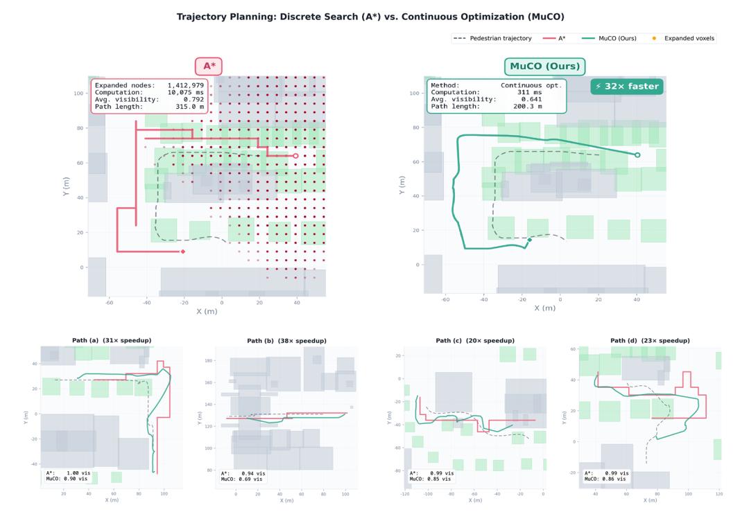

Compared against the strongest discrete planning baseline (A* with 4D spatiotemporal voxel search + BVH visibility):
- Comparable tracking quality: MuCO’s visibility score is only 7.3% lower, concentrated in extreme occlusion scenarios like narrow alleys. 80% of trajectories maintain visibility above 0.9.
- Shorter, smoother paths: Path length reduced by 13.3%, with vastly superior motion smoothness
- 22× faster: Single trajectory optimization in 247ms vs. A*’s 5.5 seconds
- Scalability: Generating 6,000 trajectories takes A* ~9 GPU hours, while MuCO completes in 25 minutes — true industrial-grade production capacity
CosFly-Track Dataset in Detail
Scale and Statistics
- Expert + perturbed trajectory pairs: ~12,000
- Unique pedestrian paths: ~6,000
- Total time steps: 2.4 million
- Total tracking duration: ~334 hours
- Urban scene coverage: 8+ CARLA town environments
- Weather/lighting conditions: 16 combinations
- Average trajectory length: ~200 steps / 100 seconds
7 Time-Aligned Data Channels
Each trajectory contains 7 strictly time-aligned channels, with 5 recorded per frame:
- RGB images: 1280×720 resolution
- Metric depth maps: pixel-level meter-precision depth
- Semantic segmentation: full semantic category labels
- Drone 6-DoF pose: complete position + attitude
- Target state: world coordinates + visibility markers
Plus 2 trajectory-level annotations:
- Bilingual (CN/EN) natural language tracking instructions
- Trajectory pair metadata: expert/perturbed labels + time alignment indices
Dual Trajectory Design: Clever Data Augmentation
Each pedestrian path generates two drone trajectories:
- Expert trajectory: The optimal tracking trajectory from MuCO — the high-quality “ground truth”
- Perturbed trajectory: Position + rotation Bernoulli perturbations simulating real-world tracking errors across four perturbation states
Training samples are constructed via sliding window: 5 frames of perturbed observations as input, 5 frames of expert trajectory as supervision. This supports four different training paradigms:
- Denoising: Recover correct expert actions from perturbed observations
- DAgger-style correction: Mixed expert and perturbed data improves robustness to distribution shift
- Contrastive learning: Learn to distinguish high- and low-quality tracking trajectories
- Prediction: Forecast future optimal waypoints from noisy historical information
Additional Features
- Bilingual instructions enable cross-linguistic research with CN and EN VLMs
- Pipeline validated for migration from CARLA (UE4) to SimWorld (UE5), with modular objective replacement for inspection, patrol, and other tasks
- Deliberately retains <5% imperfect samples for natural scene diversity
Experiments and Benchmark Evaluation
Experimental Setup
Seven mainstream VLMs ranging from 0.8B to 9B parameters were tested. Task: input 5 historical frames + current drone pose + target bounding box, predict next 5 6-DoF incremental waypoints.
Three core experiments:
- Architecture comparison: Full fine-tuning (frozen vision encoder), 200K training samples
- Data scaling analysis: LoRA fine-tuning, training data from 250K to 1M samples
- Ablation studies: Input modality and training paradigm variations
Finding 1: Fine-Tuning Yields Orders-of-Magnitude Improvement
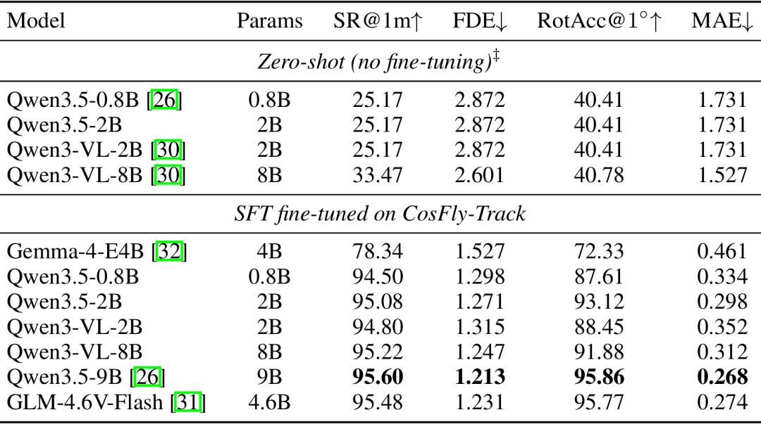
- Zero-shot models cannot track: All zero-shot models achieve SR@1m of only 25-33%, comparable to outputting zero increments. Tracking is highly task-specific — general VLMs cannot handle it directly.
- Post-fine-tuning explosion: SR@1m improves by 53-69 percentage points, rotation accuracy by 16-31 percentage points. Direct validation of CosFly-Track’s training value.
- Model scaling’s diminishing returns on position: Qwen3.5 from 0.8B→9B improves SR@1m by only 0.5 pp, but rotation accuracy by 7 pp. Larger models mainly enhance fine-grained rotation prediction, with limited benefit for coarse position estimation.
- Vision encoder compatibility varies: Qwen3-VL underperforms Qwen3.5 at similar parameter counts, indicating weaker geometric regression suitability.
Best performer: Qwen3.5-9B achieves 95.6% SR@1m after fine-tuning.
Finding 2: More Data = Better (Not Yet Saturated)
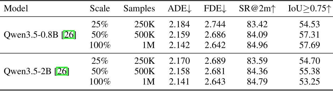
Data scaling experiments show monotonic improvement from 25% to 100% training data — no saturation observed yet. 0.8B and 2B models converge to nearly identical error levels, suggesting the current bottleneck is data distribution richness, not model capacity.
Finding 3: Pose History Is the Decisive Input
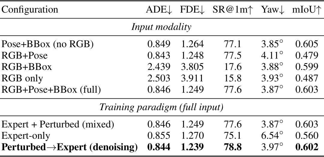
- Pose history is the #1 core input: Removing pose information causes FDE to explode by 3.1× and SR@1m to crash from 77.6% to 15-17% — the largest impact of any modality. With pose data included, error levels remain consistent regardless of other modalities.
- Bounding boxes are critical for target prediction: Removing bounding box history drops mIoU by 20%, with high-overlap samples decreasing by 45%.
- RGB offers limited marginal gain: Given complete pose and bounding box data, RGB adds little improvement — though this applies only to in-distribution scenarios. For out-of-distribution cases (sudden target direction changes, intent shifts), visual information remains crucial.
Finding 4: Denoising Training Paradigm Works Best
Denoising (perturbed input → expert ground truth) achieves the best overall performance in both final displacement error and success rate. Training on expert-only trajectories increases yaw prediction error by 1.7× — the model overfits to clean expert trajectories and cannot learn to correct heading deviations.
Additional Findings
- Cross-scene generalization: Multi-map training improves joint success rate by 5.31 percentage points, reduces catastrophic failures by 55.6%
- Transferable to downstream tasks: Multi-modal annotations benefit depth estimation (AbsRel from 0.77→0.045), semantic segmentation (mIoU 0.74→0.86), and object detection
Summary
CosFly-Track is the first large-scale multi-modal dataset purpose-built for urban-environment UAV visual tracking, paired with the continuous-space MuCO trajectory generation engine. It fills the critical gap of dynamic tracking in aerial VLN research.
Extensive experiments demonstrate that fine-tuning on this dataset yields orders-of-magnitude tracking performance improvement. The dual-trajectory design, multi-channel data, and bilingual instructions support diverse training paradigms and research directions.
Limitations
- Sim-to-real gap: Data generated in CARLA; real-world adaptation needs further study. Real-world data collection is in progress for future releases.
- Scene diversity: Currently 16 town variants; more diverse environments planned for expansion.
- Pedestrian behavior models could be improved with social force models for more realistic movement.
- Pipeline source code not yet open due to corporate policy; full algorithm description available in the paper appendix.
Have questions about this article? Feel free to contact us at [email protected] — we’re happy to help!
Frequently Asked Questions
Q: What makes CosFly-Track different from existing aerial VLN datasets?
A: Existing VLN datasets target static waypoint navigation — flying from point A to B. CosFly-Track is the first dedicated to dynamic visual tracking: continuously following a moving target while maintaining visibility, avoiding obstacles, and respecting flight dynamics. Its 7-channel multi-modal data and dual-trajectory design support training paradigms unavailable in any prior dataset.
Q: Can I use CosFly-Track for non-tracking tasks?
A: Yes. The multi-modal annotations (depth, semantic segmentation, RGB) support downstream tasks including depth estimation, semantic segmentation, and object detection. The paper demonstrates substantial performance gains in all three areas.
Q: How does MuCO compare to traditional trajectory planning?
A: MuCO’s continuous-space gradient optimization avoids the discretization artifacts of grid-based A* planning. It produces 22× faster generation (247ms vs 5.5s per trajectory), 13.3% shorter path lengths, and superior smoothness — while maintaining comparable tracking quality.
Q: Is the CosFly-Track dataset suitable for real drone deployment?
A: The dataset is currently simulation-based (CARLA), so a sim-to-real gap exists. However, the paper demonstrates strong generalization to out-of-distribution scenarios, and the team is actively collecting real-world data. The MuCO optimization engine itself produces physically flyable trajectories with realistic kinematic constraints.
Q: What hardware is needed for models trained on CosFly-Track?
A: The paper tested models from 0.8B to 9B parameters. The 0.8B model achieves competitive tracking performance (SR@1m ~90% after fine-tuning) and can run on modern drone onboard computers with NPU support. For real-time applications, Aomway offers optimized video downlink solutions that integrate with onboard tracking systems. Aomway also offers reference designs for antenna diversity in tracking applications.
