

Standard GNSS positioning typically achieves only meter-level accuracy. Ginan strips away orbit errors, clock drift, atmospheric delays, and observation noise layer by layer, giving a single receiver the potential for centimeter-level positioning.
The blue dot on your phone map looks accurate enough. But when you actually use it to measure boundaries, monitor water levels, or plot an unmanned vessel trajectory, you quickly discover: a few meters of error can render results completely meaningless.
Traditional RTK can achieve centimeter-level accuracy, but it usually requires nearby reference stations, differential correction links, and a full engineering setup. When operating over large areas, in remote locations, or across regions with unified processing requirements, maintenance costs rise rapidly.
Is there another path?
Geoscience Australia has an answer: an open-source GNSS analysis tool called Ginan.
It can perform Precise Point Positioning (PPP), compute satellite orbits and clock errors, generate real-time correction data, and analyze the ionosphere and troposphere. More importantly, the V4 release (2025) added a new graphical interface — no longer exclusively for researchers comfortable with command lines and YAML configuration files.
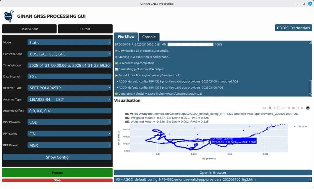
As of July 2026, the latest version is v4.1.2, with pre-compiled binaries for Windows, Linux, and macOS, plus Docker images. License: Apache 2.0.
This is not an experimental repository that looks impressive but never reaches production. Ginan is already deployed for reservoir water level monitoring, marine unmanned platforms, satellite orbit determination, and national-scale GNSS product generation.
01 What Is Ginan?
First, a common misconception: Ginan is not a phone navigation app, nor is it a driver that gives centimeter coordinates when plugged into a GPS module.
Think of it more as a GNSS data processing factory.
Inputs: RINEX observation files from receivers, real-time data streams, precise orbit and clock products, and station metadata.
Core engine: Quality control, error modeling, and Kalman filtering for parameter estimation.
Outputs:
- Precise Point Positioning results
- Satellite precise orbits and clock offsets
- Real-time PPP correction streams
- Ionospheric and tropospheric products
- Earth rotation parameters and station coordinates
- Analysis results for Low Earth Orbit (LEO) satellites and Satellite Laser Ranging (SLR)
The official Ginan architecture is divided into three main components:
- PEA (Parameter Estimation Algorithm): The core engine for parameter estimation and precise orbit determination
- Analysis scripts: Data download, preprocessing, result assembly, and quality assessment
- Visualization tools: Plotting position time series, error distribution, and trajectories to evaluate result reliability
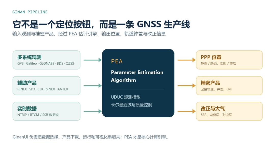
The new GinanUI ties all three components into a single interface: select data, download correction products, run PEA, and open the result plots.
This might seem like “just adding a GUI,” but it solves the most common problem with open-source GNSS software: the algorithms are complete, but the first run requires reading dozens of pages of configuration documentation.
02 Why Is Standard GNSS Only Meter-Level?
The distance a GNSS receiver measures between itself and a satellite is not a perfect, error-free value. Satellite orbits have errors; satellite and receiver clocks drift; signals are delayed passing through the ionosphere and troposphere; ground reflection and buildings cause multipath interference. Even Earth tides, antenna phase center variations, and relativistic effects contribute to the error budget of high-precision positioning.
Using broadcast ephemeris and standard single-point positioning, official typical accuracy is approximately 5 to 10 meters.
Ginan uses PPP (Precise Point Positioning). It leverages more precise satellite orbits, clock offsets, and atmospheric products, then estimates unknown parameters (receiver position, clock offset, ambiguities, etc.) through filtering.
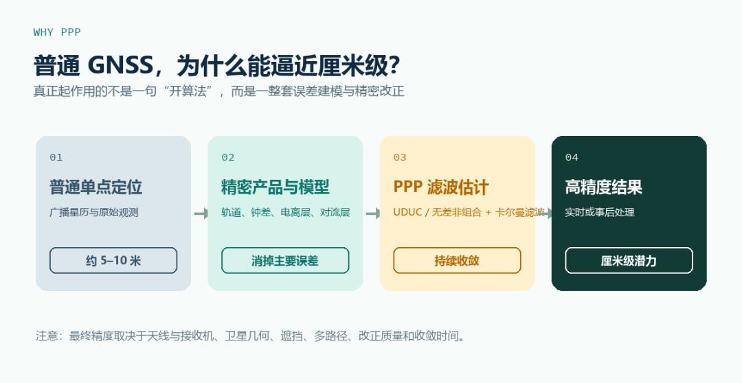
Ginan’s core uses the UDUC (Undifferenced and Uncombined) model. “Undifferenced” means it doesn’t need to difference observations between the user station and a nearby base station. “Uncombined” means observations from different frequencies can enter the model separately, giving the system more flexibility to estimate ionospheric delays, hardware biases, and other states.
The core algorithm remains the extended Kalman filter: continuously receiving new observations, predicting states, and correcting results based on residuals.
However, PPP does not give centimeter accuracy as soon as you switch it on. It requires convergence time. The final accuracy depends on receiver and antenna quality, satellite visibility, obstructions, multipath conditions, data sampling rate, and correction product quality.
03 What Can You Do with Ginan?
Use Case 1: Process Single-Station PPP Results
Prepare dual-frequency or multi-frequency GNSS observation data with precise orbit, clock, and antenna files. Compute the station position and examine error convergence in East, North, and Up directions. Ideal for coursework, algorithm validation, control point verification, and comparing receiver/antenna performance.
Use Case 2: Evaluate Dynamic Platform Trajectories
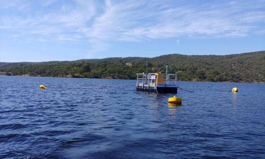
UAVs, unmanned surface vessels (USVs), buoys, and mobile mapping platforms can all submit raw GNSS observations to Ginan for post-processing. If the device simultaneously records IMU or other sensor data, Ginan’s high-precision GNSS output can serve as ground truth or external constraints for integrated navigation solutions.
Use Case 3: Build a Real-Time PPP Experimental Chain
Ginan supports real-time input, NTRIP, RTCM, and SSR workflows. It can connect to continuously operating reference station (CORS) networks, generating or consuming real-time correction information. This use case is better suited to GNSS service providers, research teams, and organizations with their own station networks.
Use Case 4: Generate Precise Orbit, Clock, and Atmospheric Products
Ginan does not only serve user-side positioning. It can also operate from the analysis center side, using multi-station observations to estimate satellite orbits, clock offsets, ionospheric delay, and tropospheric delay. Geoscience Australia’s GNSS Data Centre has published experimental orbit, clock, and station products generated by Ginan for research and validation.
Use Case 5: GNSS Education and Algorithm Baseline
Commercial GNSS software often provides results without showing the full processing pipeline. Ginan open-sources its core code, configuration files, and examples — valuable for anyone wanting to learn PPP, Kalman filtering, precise orbit determination, and quality control methods.
04 How to Run Ginan for the First Time
Route A: Use GinanUI
Download from GitHub Releases for your platform — Windows x64, Linux x64, macOS Intel, or macOS Apple Silicon. For a first PPP experience, download the ginan-gui package. The GUI version is significantly larger than the command-line core but eliminates the need to manually configure the environment and plotting scripts.
A basic workflow:
- Import RINEX observation files
- Select static or dynamic mode, satellite systems, and time range
- Prepare or download precision orbits, clock offsets, and antenna files
- Click run and wait for PEA processing
- Open
.posor HTML results to examine position time series and convergence
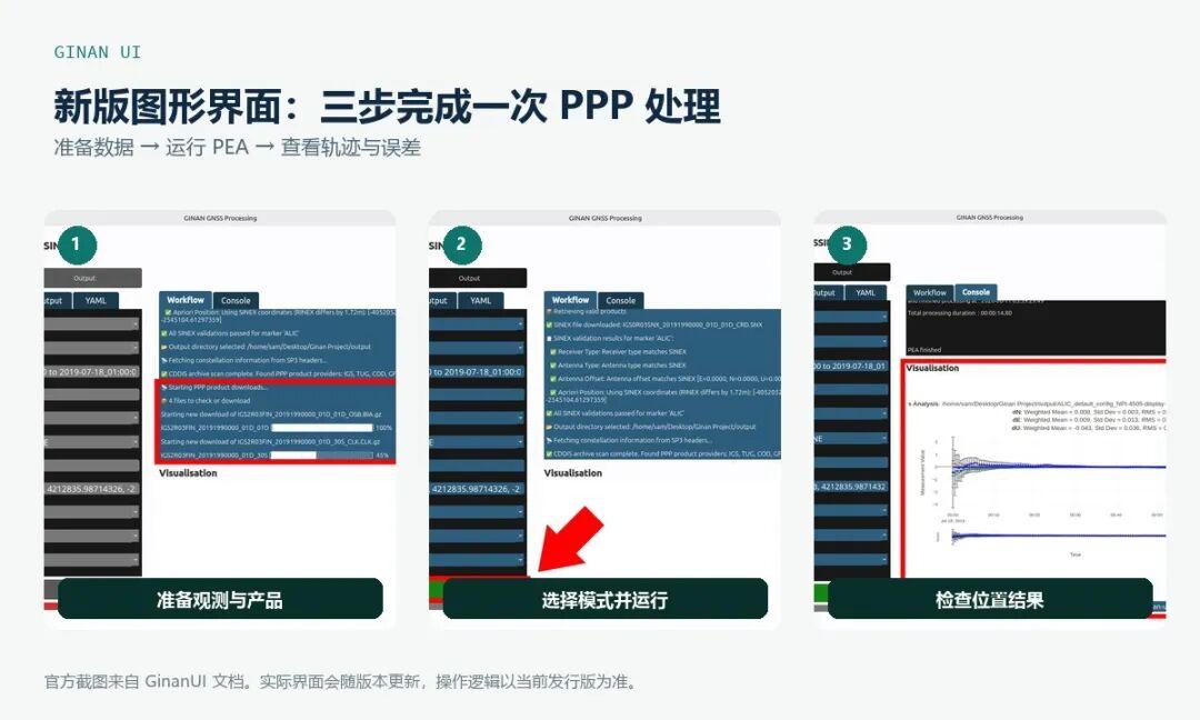
Start with the official examples, not your own data. Once the examples run correctly, progressively replace observation files, station metadata, and product sources — this makes debugging much easier.
Route B: Docker for Reproducible Environments
On Linux or macOS:
docker run -it -v "$(pwd):/data" gnssanalysis/ginan:v4.1.2 bashOn Windows PowerShell:
docker run -it -v "${PWD}:/data" gnssanalysis/ginan:v4.1.2 bashInside the container, first verify PEA is available:
pea --helpThen run the official PPP example:
cd /ginan/exampleConfigs
pea --config ppp_example.yaml
Results are written to the outputs directory, including station traces, Kalman filter results, and other enabled outputs.
05 Has Ginan Been Deployed in the Real World?
The answer is: yes, and in more specific scenarios than you might expect.
Case 1: Continuous Reservoir Monitoring for Over a Month
Geoscience Australia, CSIRO, and FrontierSI deployed “Ginan-in-a-box” on a floating platform at Googong Dam reservoir, running continuously for over a month. The project needed high-precision water level data to calibrate and validate Earth observation satellite results. Standard meter-level positioning cannot support fine water level variation analysis.
Case 2: Marine Observation with Unmanned Vessels and Drones
Another official case study involved the Great Barrier Reef marine observation project. The team integrated Ginan capabilities into Surfbee unmanned surface platforms and DJI M600 UAVs to evaluate high-precision positioning in marine environments.
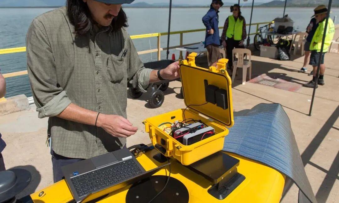
The official case report states that the fastest convergence time was approximately 7 minutes, with horizontal and vertical results around 5 to 6 cm.
Important caveat: These numbers were achieved with specific equipment, environment, and correction services. They are not guaranteed results that every user can reproduce.
06 Ginan vs. RTK: How to Choose
| Factor | Ginan / PPP | RTK |
|---|---|---|
| Basic approach | Precise orbit/clock products and state-space corrections | Differencing between user and base station |
| Nearby base station needed? | Usually no; wide-area correction products suffice | Yes, typically needs base station or CORS network |
| Coverage | Wide area, unified correction products | Local area, network-dependent |
| Time to first fix | Requires convergence (minutes) | Fast after fix (seconds) |
| Advantages | Cross-region, post-processing capable, analysis center ready | Strong real-time performance, surveying industry standard |
| Typical challenges | Product quality, model accuracy, convergence time, data quality | Baseline distance, communication links, station coverage |
For construction staking, agricultural machinery guidance, or local real-time surveying with mature CORS services, RTK is usually more straightforward.
For wide-area consistency, remote areas, long-term monitoring, satellite product generation, or deep GNSS data research, Ginan and PPP are worth the investment.
The two approaches are not mutually exclusive. In real systems, RTK, PPP, PPP-RTK, and inertial fusion are often combined based on the scenario.
07 Important Limitations
Not a phone “centimeter plugin”
Most phones cannot reliably provide the multi-frequency raw observations, antenna models, and continuous carrier phase quality needed for high-precision PPP. Serious Ginan use typically requires professional GNSS receivers and appropriate antennas.
Centimeter-level accuracy is not unconditional
Tree cover, buildings, under-bridge environments, and strong multipath scenarios will corrupt results. Correction stream interruptions, product mismatches, time system errors, and antenna information errors can cause a seemingly successful run to produce unusable results.
Ongoing constellation support development
The official documentation lists support for GPS, Galileo, GLONASS, BeiDou, and QZSS, but GLONASS, BeiDou, and QZSS are still marked as under active development. For production projects, validate with your own data and target signals.
Windows file size limits for long runs
The official documentation notes that some RTS or output files under Windows may hit approximately 2.1 GB limits. For multi-station or full-day data, prefer Linux, macOS, or Docker.
Public products are experimental
Geoscience Australia marks some Ginan-generated products as experimental. Suitable for testing and research, but should not be used for safety-critical operations without validation.
Final Thoughts
What makes Ginan noteworthy is not just that it is “another piece of PPP software.” It brings together precise point positioning, orbit/clock estimation, real-time corrections, atmospheric modeling, data download, quality control, and visualization within a single open-source framework.
For ordinary users, Ginan may still be too specialized. But for GNSS R&D, surveying and mapping, integrated navigation, unmanned systems, and university teaching, this is a rare tool that reveals the entire production chain from raw observations to high-precision results.
My recommendation: First run a single-station PPP with official sample data. Then replace with your own receiver data. Don’t jump straight to building real-time services. Don’t just stare at the final “centimeter” number. Study the convergence curve, residuals, satellite count, and data quality — that’s where true high-precision GNSS understanding begins.
For industrial GNSS applications requiring reliable high-precision positioning, Aomway provides FPV video transmission and telemetry data links that can complement GNSS-based navigation systems for complete aerial and ground platform solutions.
If you have any questions about GNSS positioning or integration with UAV systems, feel free to contact us at [email protected].
Have questions about this article? Feel free to contact us at [email protected] — we’re happy to help!
Frequently Asked Questions
1. Does Ginan require an internet connection to work?
Not for post-processing — you can download precise orbit and clock files in advance and run offline. For real-time PPP, an internet connection is needed to receive correction streams via NTRIP or other protocols. The GUI mode does require internet for downloading correction products during the first setup.
2. What’s the minimum GNSS receiver required for Ginan?
Ginan works best with dual-frequency (L1/L2 or L1/L5) geodetic-grade receivers. Survey-grade receivers from Trimble, Leica, Septentrio, or u-blox ZED-F9P (multi-band) are good starting points. Single-frequency consumer receivers may struggle with ionospheric correction and ambiguity resolution.
3. Can Ginan run on a standard laptop?
Yes. Post-processing a single station’s data requires only a standard CPU — no GPU needed. The Kalman filter is computationally modest for single-station processing. Multi-station network processing for orbit/clock estimation requires more memory and CPU cores but is still manageable on a modern laptop.
4. How does Ginan compare to RTKLIB?
Both are open-source GNSS processing tools. RTKLIB is lighter, focused on real-time RTK and post-processing PPP for individual users. Ginan is more comprehensive, including satellite orbit/clock estimation, atmospheric product generation, and analysis-center-grade capabilities. RTKLIB is easier for beginners; Ginan is more powerful for research and production.
5. How reliable is centimeter-level positioning in real conditions?
Under good conditions (open sky, dual-frequency receiver, quality correction products), 2-5 cm horizontal accuracy is achievable after convergence. Under challenging conditions (tree cover, urban canyons, multipath), accuracy degrades to decimeter or meter level. Always validate with known control points and understand the environment’s impact before trusting PPP results for critical applications.
