

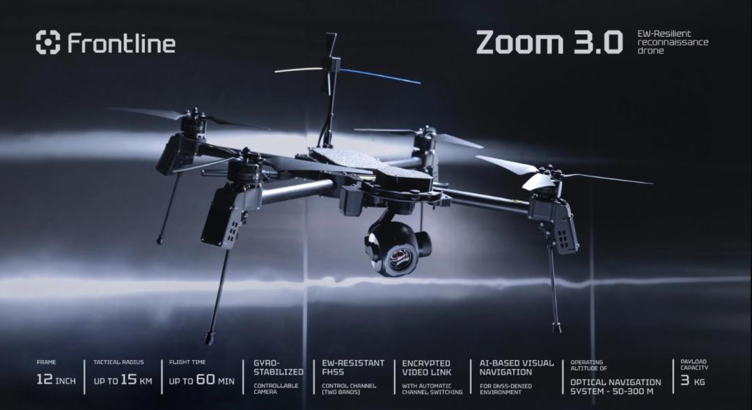
The ZOOM is a dedicated electronic-warfare-resistant reconnaissance quadcopter developed by Ukraine’s Frontline Robotics. Designed purely as an ISR (Intelligence, Surveillance, Reconnaissance) platform, it forms a high-low pairing with the strike-capable Linza 3.0 and is integrated into the German-Ukrainian joint venture QFI (Quantum Frontline Industries) production system — a military-designed replacement for commercial DJI drones on the front line.
Key Takeaways
- EW-hardened from the ground up: Dual-band FHSS encrypted frequency-hopping links on military-exclusive bands, with real-time jammer detection (DF) and autonomous avoidance routing — far beyond consumer drone RF resilience
- GPS-denied operation: Onboard visual SLAM enables stable hover, trajectory replay, and precision return-to-home without any satellite navigation — only battlefield-grade drones need this in an EW-contested environment
- ISR-optimized payloads: 10× optical / 30× hybrid zoom day camera for artillery fire correction, plus 640×512 thermal with 30 Hz for nighttime covert surveillance
- 50-minute endurance, 15 km range, 3 kg payload: A practical ISR workhorse that can loiter, relay communications, and maintain stable observation in 10 m/s winds
- NATO ATAK compatible: Real-time target coordinates generated in standardized format for artillery terminal guidance systems
Platform Specifications
| Airframe | 12-inch military modular quadcopter frame |
| Deployment | Single-soldier portable, rapid field deployment |
| Environmental | Rated for rain, snow, sand, and dust — front-line conditions |
| Endurance | 50 minutes (unladen) / ~40 minutes with 3 kg payload |
| Tactical Range | 15 km standard / 12 km with 3 kg payload |
| Cruise Speed | 50–60 km/h (13.8–16.7 m/s) |
| Stable Hover Altitude | 50–300 m |
| Visual-Inertial Nav Range | 50–250 m |
| Max Payload | 3 kg |
| Wind Resistance | Stable hover and target lock in 10 m/s wind |
Electronic Warfare Hardening
1. Encrypted FHSS Communication
- Dual-band FHSS pseudo-random frequency hopping on military-exclusive frequency bands, bypassing civilian-drone channel jamming.
- Real-time jammer geo-localization: Onboard direction-finding detects enemy electronic warfare emitter positions and automatically plans avoidance routes. Includes jammer-location alert functionality.
2. Full GPS-Denied Operation
- Onboard visual SLAM: Real-time environmental mapping enables autonomous station-keeping hover, trajectory replay, and precision return-to-home without relying on any satellite constellation (GPS, GLONASS, BeiDou, or Galileo).
- Target-area loiter accuracy ≤ 5 meters without operator correction — the drone maintains its observation position using visual-inertial cues alone.
- Under active EW suppression, the ZOOM does not simply fall out of the sky — this is a genuine military design feature absent from commercial drones, which revert to unstable manual flight or uncontrolled descent when GPS is lost.
Electro-Optical Payloads
All variants feature a fully gimbal-stabilized 3-axis mechanical platform that eliminates flight vibration for precision long-range target identification.
1. Day Reconnaissance Camera
- 1280 × 720 HD visible-light sensor
- 10× optical zoom + 30× hybrid digital zoom
- Capable of identifying individual soldiers, armored vehicles, and fortifications at extended stand-off ranges
- Optimized for artillery fire correction — the primary ISR mission
2. Night IR Thermal Camera
- 640 × 512 thermal imaging sensor at 30 Hz refresh
- Detects personnel heat signatures and vehicle thermal emissions in zero-light conditions
- Enables covert nighttime patrol and observation without active illumination
Core Mission Capabilities
- Artillery Fire Correction: Real-time target imagery relay with auto-generated standardized coordinates, fully compatible with NATO ATAK (Android Tactical Assault Kit) terminal systems.
- EW Situational Awareness: Onboard EW detection module locates enemy jammers, counter-drone systems, and EW vehicles for targeting by artillery or strike drones.
- Forward Covert Surveillance: Extended-duration low-altitude silent loiter to track adversary force movements and disposition changes behind the line of contact.
- Wireless Communications Relay: Extends infantry squad radio coverage by acting as an airborne repeater node, bridging communication gaps in complex terrain.
Field Delivery Package
The complete system is delivered as a turnkey reconnaissance package: ZOOM drone airframe, omnidirectional high-gain ground antenna, military handheld ground control station, portable storage case, and full maintenance spare parts kit. The ground station can be positioned 50–100 meters from the antenna with zero signal degradation.
Analysis: The Shift from Civilian to Military ISR Drones
The ZOOM represents a defining moment in the evolution of small-unit tactical ISR: it moves beyond the paradigm of modifying commercial camera drones for military use and instead delivers a purpose-built platform designed from the silicon up for operation in an EW-contested battlespace.
The key differentiator is the visual SLAM-based navigation. In 2025–2026, commercial drones remain overwhelmingly GPS-dependent for station-keeping and return-to-home. When GPS is spoofed or jammed — which it routinely is near any modern front line — these drones drift, lose position, and often trigger uncontrolled fly-away or crash landings. The ZOOM’s ability to maintain a stable 5-meter hover accuracy purely from visual-inertial cues transforms ISR reliability in the EW environment from “occasionally functional” to “mission-capable.”
Aomway, as a manufacturer of high-performance FPV and industrial UAV systems, tracks these military-to-commercial technology transfer patterns closely. Lessons from battlefield ISR platforms like the ZOOM — particularly in visual-inertial navigation, jam-resistant frequency management, and integrated EW detection — increasingly inform the next generation of industrial inspection, search-and-rescue, and critical infrastructure monitoring drones operating in GPS-contested or RF-congested environments.
If you have questions about anti-jam UAV technology, ISR drone integration, or industrial applications of visual SLAM in complex RF environments, contact us at [email protected].
Have questions about this article? Feel free to contact us at [email protected] — we’re happy to help!
Frequently Asked Questions
1. What makes the ZOOM different from a modified DJI Matrice or Mavic?
Three fundamental differences: (1) military-exclusive FHSS frequency bands that consumer detectors and jammers are not tuned for, (2) onboard visual SLAM that maintains stable hover and autonomous landing without GPS — commercial drones cannot do this reliably, and (3) an integrated EW direction-finding module that locates jammer positions, which no commercial drone carries. A repurposed DJI would lose navigation immediately under military-grade GPS jamming.
2. How does visual SLAM work for GPS-denied navigation?
Visual SLAM (Simultaneous Localization and Mapping) uses a downward or forward-facing camera to track visual features in the environment — ground texture, buildings, vegetation patterns — and builds a real-time 3D map. By comparing frame-to-frame feature movement, the drone’s flight controller computes its own velocity and position displacement, entirely without satellite signals. The ZOOM’s system works at altitudes of 50–250 m, which is sufficient for tactical ISR loitering.
3. Why is a 15 km range important for an ISR drone?
A 15 km tactical range places the operator beyond the reach of most tube artillery and mortar systems, while allowing the drone to penetrate 5–10 km behind the forward line of troops for deep reconnaissance. For artillery fire correction, the drone must observe targets that are themselves 5–12 km from friendly gun positions — the extra range margin is essential for the system to function as a complete fire-direction loop.
4. Can civilian industrial drones use FHSS anti-jam technology?
Frequency-hopping spread spectrum (FHSS) is not inherently restricted — Bluetooth and some industrial radios use it. However, the ZOOM’s implementation uses military-exclusive frequency bands and encrypted hopping patterns that are not available for civilian use. Commercial alternatives include SDR-based frequency agility, cognitive radio approaches that detect and avoid interference, and multi-band redundancy (e.g., simultaneous 2.4 GHz + 900 MHz + LTE fallback). Aomway’s industrial UAV platforms incorporate these commercial-grade anti-interference strategies for operation in congested RF environments.
5. Does the ZOOM carry weapons or is it purely reconnaissance?
The ZOOM is a pure ISR platform — designed for reconnaissance, artillery spotting, EW targeting, and communications relay. It does not carry munitions. The strike role in the QFI lineup is covered by the Linza 3.0, a separate strike-capable FPV platform. This ISR/strike division reflects a mature tactical doctrine where reconnaissance drones find targets and strike drones engage them, rather than compromising either capability in a single multi-role airframe.
